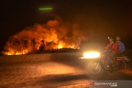
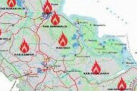
Pekanbaru (Antarariau.com) - NASA s Aqua and Terra satellites detected 65 hotspots of forest fires across Sumatra Island with an accuracy rate at 50 percent, on Saturday morning.
The number increased from 51 hotspots on the previous day, Slamet Riyadi of the Pekanbaru meteorology station, said here, Saturday.
"Nearly 94 percent, or 61 hotspots are concentrated in Riau Province. The rest are in Lampung Province with three hotspots, and one in West Sumatra," he said.
In Riau, the hotspots were found in the districts of Rokan Hilir (36), Siak (13), Bengkalis (nine), Rokan Hulu (two), and Kampar (one).
In Rokan Hilir, wildfires have produced thick smoke haze that shrouded the sub-districts of Mandau and Pinggir, and reduced visibility to 150 meters.
Most of the fires came from local farmers who practiced slash and burn method to open farmlands mostly in peatland area, according to reports.
Over the past two weeks in Bengkalis, a joint team comprising among others 60 Riau mobile brigade personnel, 25 police officers of Pinggir police sector, 10 military personnel, 10 fire fighters, and 100 local residents, have done their utmost to extinguish the fires.
In line with the Law No. 32 Year 2009 on Environmental Protection and Management, forest and plantation arsonists could face up to 15 years in jail and a fine worth Rp15 billion maximally if the fire claims casualties.
On Saturday morning, the districts of Dumai and Pekanbaru and several other towns were also shrouded by haze.
Haze reportedly also spread to neighboring country, Singapore.
The Indonesian Air Force based in Pekanbaru, has deployed four helicopters each with a water carrying capacity of four to five thousand liters, and two air tractors having capacity of carrying 3,100 liters of water, to carry out water bombing activities to put out the fires.
Satellites Detect 65 Hotspots On Sumatra Island


